Farmers can now see plant health and pest infestation changes in even small groups of plants—and directly do something about it on demand.
In the past, land-based automated systems would face public roads, people, and animals in addition to the literal bumps, ditches, fences, and gouges found in and among productive plots of farmland. The freedom of aerial maneuvering allows drones to fly over these obstacles. Additionally, aerial systems, by their nature, get a bird’s eye view, perfect for surveying, scanning, and mapping.
Choosing the Best Drones for Farming
There are some special requirements and farm-specific considerations when it comes to choosing the best ag drone for your operation. Larger drones are generally better for farming because they can carry more chemistry and fly for a longer period of time before needing a recharge. Additionally, farmers looking to use drones need to know why some tools are required and why an all-purpose hobby drone without modifications will usually not fit the bill.
The least technical reason for getting a costlier drone is because a bigger “truck in the sky” can carry more, but there is also a solid reason to look a bit more closely at the technology. Drones might actually earn profits just by providing spray applications on autopilot, but the fundamental idea is to spray (or not spray) based on a very precise survey of each plot; the point is to find pests or underperforming plants right away with exact detail and respond immediately. Although PhDs in rocket science aren’t required, some special gear and software are needed.
Farming with Drones: Survey and Inspection Drones
Cameras equipped with specialized sensors see what standard cameras can’t see, generating images that provide the best insight into plant health and productivity. To this end, most agriculture drones carry two cameras simultaneously for mapping runs.
Two terms are quite common in most agricultural stories about drones, and both require at least a basic introduction: NIR and NDVI.
NIR and NDVI Drone Camera Technology
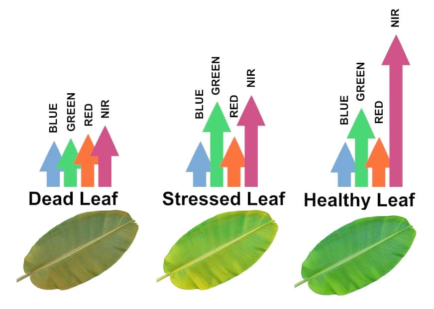
The clearest special requirement that takes cheap drones off the table is the use of “NIR” or “Near Infrared” cameras because it’s infrared scanning that most clearly showcases plant health and spotlights problems. Standard cameras won’t cut it.
Inexpensive drone companies sometimes attempt to make standard cameras show NIR results by filtering and interpolating scan data, but this approach has limited success in very narrow areas of the light spectrum. Farmers searching for a “cheap deal” will have to face the fact that typical hobby or photo drones carry cameras made to see the way human eyes see, and such cameras can’t see deeply into the infrared spectrum.
The ability to see full infrared data is critical to getting a clear picture of field health and problem areas.
The other hype word floating about in drone literature is “NDVI,” and once again, this concept does not require advanced degrees or help from government space agencies.
NDVI stands for “normalized difference vegetation index.” Basically, this is a comparison technique that looks for differences between infrared images. At heart, NDVI is no more complex than looking at some photos to see the differences between image A and image B.
The colors on NDVI images represent different types of plants, plant health, and the type of ground; it’s possible (and often relatively easy) to see the difference between healthy plants and plants with problems, for instance. But there can easily be a spanner in the works, so to speak, since the lighting and ambient temperature data from a flight on the first Tuesday of May will not be the same as in the second week of June. Even without considering issues like cloud cover, the two images will have visual differences even if there is no difference in the condition of the plants.

Last but not least, some software is required to make sense of the imagery. If nothing else, flight images must be “stitched together” to make full map layouts of the fields in question. Software is tagged to GPS data for accuracy, so even if an image is taken during a wind gust, images will still be perfectly melded together.
Farming with Drones: The Workhorse Drones
Tractor spray rigs and backpack sprayers can be stored away; flying robots are affordable and don’t need paychecks.
Once surveys have located plants with issues, drones are the tool for applying spray solutions. Drones are much smaller than planes and helicopters, of course, so they have to be refilled and recharged, but on a dollar-for-dollar basis, drones outperform every other method available by wide margins. Drones deliver with perfect GPS precision, and on large properties, a single drone technician can keep several spray drones in the air at one time to maximize field time. Adequately equipped, one technician can apply individualized solutions to half a dozen fields simultaneously—or more.

How Can My Drone Services Help?
My Drone Services have tested and used many of the agricultural drone gear needed to tackle any plot from small acreage to megafarming—and our agriculture drone services team has the expertise to help you navigate the many choices. Our goal is to get you up to speed and help you grasp the basic concepts so you can make drones pay actual dividends.
Precision farming is a money-making reality thanks to these flying ‘bots that tirelessly perform multi-wavelength monitoring and precision spray application nearly on a one-plant-at-a-time level. And it’s our life mission to put advanced versions of these machines to work for you as the reliable everyday workhorses they can be.
Increase your Farm Yield
Contact us to discover how drones can put better yields and bigger profits on your bottom line!

Leon Shivamber
Partner
Advisor, Entrepreneur, Strategist, & Transformation Agent

Brad Nichols
Partner
30 plus years focused on mission-critical technology and operations
