Improving crop health and yields
Tailored for agricultural needs.
We have years of field experience with drones in agriculture.
Agriculture Drones: Our Agricultural Services:

Our agriculture drone services deliver real value by pinpointing ways to reduce crop input and boost yield; at the end of the day, we help you produce bigger, better crops and increase profit.
We make it easy for you to access agricultural intelligence. Whether you fly your own agriculture drone in combination with our data processing or choose one of our complete solutions, we’re a perfect fit for your plans.
Precise data from agricultural drone monitoring allows you to optimize inputs and drive down costs on a large scale. Our drone-enabled solutions are cost-effective and backed by state-of-the-art equipment, giving you the rapid tools you need for your agricultural program.
Whole-field, seasonal, and current condition data provide some of the most valuable information in a precision program. With this data in hand, the savvy farmer can spot problems early and select best-fit adjustments.
Avoiding crop losses through early pest and condition identification, rapid assessment after weather events, and staying on top of crop responses to precision applications are core ways growers can turn drone services into increased profits at harvest.
Our agriculture drone services provide complete, fully integrated drone solutions that include everything needed so you can take full advantage of cutting-edge ag tools. Come up to 21st-century speed and experience how gathering faster and more accurate information leads to identifying and treating problems early and with greater precision.
We provide complete customized systems set up to fit your needs, and every set-up integrates the agricultural drone of your choice with rugged cases, modified and tuned sensors, top-notch documentation, and agriculture-specific support. Every system is provided with our matched software analysis platform to turn drone data into reports and data that integrate directly into most farm management systems.
Drones in Agriculture: A game-changer for Agribusiness
Agricultural drones represent a new and much faster way to collect field data. The most compelling reason for using agriculture drones is that data is on demand; whenever and wherever needed, agricultural drones can be easily deployed to gather up-to-the-minute information. These crop drones in the growing fields today are back-of-the-truck equipment, bringing advanced growers crucial information faster than ever before.
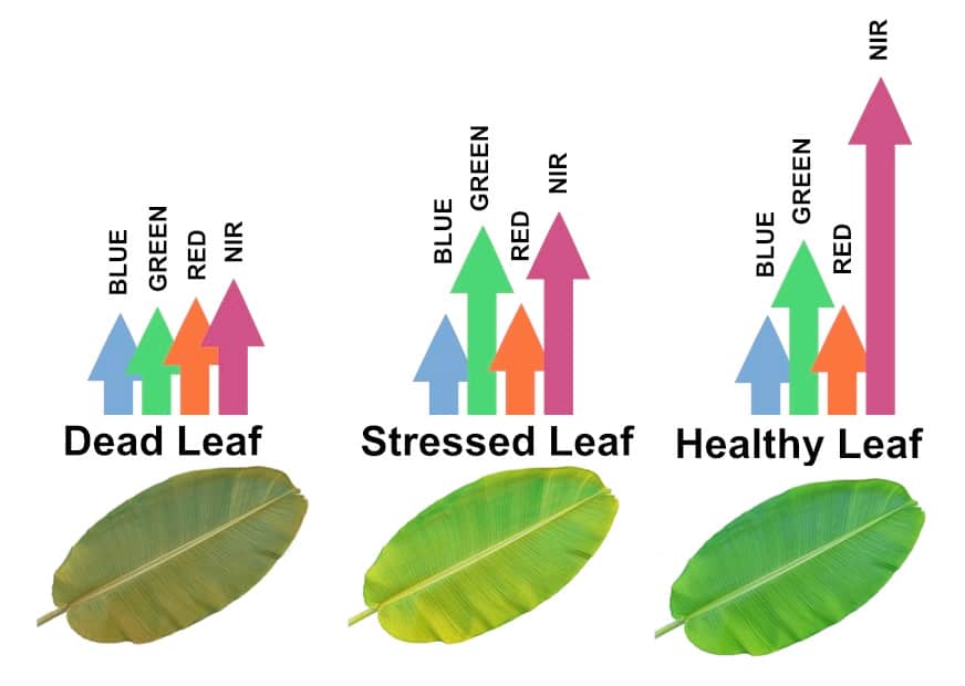
Agricultural drones permit better-than-satellite information on demand. Analyzing images with Normalized Difference Vegetation Index (NDVI) algorithms yields extremely accurate crop mapping, all without pilots, planes, or satellites. Multiple sensor studies produce perfectly focused data, too, as RGB, red edge, near-infrared, and other spectral analysis tools can reveal crop health and maturity, soil moisture, and environmental stress when and as required.
Especially in comparison with flight operations, agricultural drones provide highly specialized and detailed data at significant cost savings, allowing operations to expand monitoring and analysis significantly. Notably, drone operation has also become fairly simple thanks to self-guided flight. Current drone models are proving sturdy and reliable in the field as well, making them easy to integrate into the crop-scouting workflow. Field missions become highly time-efficient, too, as agricultural drones are “launch and forget” tools, allowing management to multitask while the drone works on a robotic program.
A simplified process:
- Initial Survey. Defining the edges of each field for the drone nav system by GPS is the basis for every operation. Once done, flight parameters are uploaded to the drone via a wireless link. Surveys are only required for the first flight and are saved to the on-board system.
- Flight. The agricultural drone launches and executes the full survey flight automatically, returning to the start point to land.
- Upload. After a round of flights, upload the information for data processing.
- Analyze. Within hours, you’ll get an email alert; your results are available for viewing and download.
How Agricultural Drones are revolutionizing farming:
Cost-effective targeting
Reduce environmental impact by targeting control applications precisely.
Environmental Improvement that saves money. Better eco-management
Even the safest farm chemistry generates runoff, so cutting back thanks to precision monitoring does more than save supplies spending!
A fundamental change. Wondering why honey got so expensive?
Precisely targeted spray application lessens the impact of sprays across the board—including a smaller impact on beneficial pollinating insects.
Our state-of-the-art. We deliver ultra-precise aerial spraying.
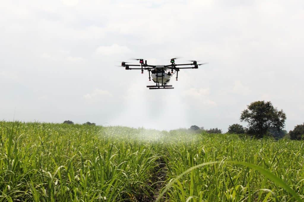
Aerial spraying will never be the same! Guided by artificial intelligence, low-altitude drone spraying results in remarkably precise delivery control.
Cost-effective solutions.
Spraying with specialized farming drones instead of aircraft is the best option for both precise control and cost, with 20% or more benefits across the board. No pilot, no airplane, little-to-no wind carry, little-to-no materials loss.
- MAP YOUR ROUTE. Our precision software helps you precisely map the route. Your agriculture drone will automatically return home when the batteries or tank run low, and the drone resumes in place automatically.
- RE-FUEL AND RECHARGE. Have a large area to manage? Even with smaller materials tanks, agriculture drones remain more efficient than aircraft for mid- to large-plot fields. Recharging systems one after another, a single worker can manage up to ten agriculture drones at once from a single “home” landing spot.
- GET DETAILED REPORTS. Detailed reports follow every application or mission, so you will quickly and easily be able to spot potential problems and monitor and maintain plant health.
Spray and Monitor: No matter the shape of the field or the type of crop.
Thanks to programmed flight paths, you’ll know every inch and every plant at whatever level of detail you need. Manage and monitor any strip of land in any shape. Spray-equipped agriculture drones are also sensor-equipped, so you get full reports to track and analyze your crops for water management, environmental stress, leaf death, pest damage, and more—in one pass.
Advanced Leaf Coloration Reports.
With our top-shelf integrated hardware and software, you can rapidly estimate the density of photosynthetically active biomass.

Curious about Agriculture Drone Solutions? Then…
or…